
Wednesday 28 April 2010
Goods Shed
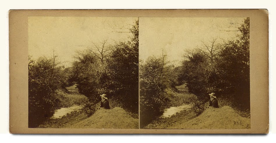
As promised an image of a similar goods shed arrangement. This seems to fit with how ours would have been. Looks like this might have been a fairly standard Midland Railway arrangement as this example is c.1865 MR in Bakewell. There is an extension although with an entrance on the end in this case and a few other variations.
Goods Shed details
In the c1940s photo in LfV the extension is reached up a flight of steps that look remarkably like the ones that are there today. I assume the current ramp was added to the right-hand door to wheel post trolleys up whereas previously a truck would have been backed up to the bay as in the current postal depot.
Rail Yard Buildings

Attached is a detail from the 1887 OS map which shows an/the extension to the eastern end of the Goods Shed. Given that the line opened to goods on May 19th 1879 and the OS map was surveyed maybe a year or two before its release, it would seem that there was an extension there well within ten years of the line opening. With regards to levels, the map doesn't show any platform at the NW end (although there is a blank square shown). Given that the map shows the actual station platforms you would think that if there was a platform it would be marked.
 Also made some enquiries about the beam arrangement in the Goods Shed and so far have this: "This most likely held the vertical beam of the crane inside the shed. The jib would be attached to the base of this. There should be some sort of indication where the base of this beam was held. Some cranes were free standing but others were of the type described."
The levels in the building are really puzzling but if the comments about the crane's base are right then it could be that the interior platform is a later addition. There certainly wasn't the yard-side ramp there until after c1940s - a photo in LfV shows this but it does show a raised deck inside the shed, given that by then they were dealing with post sacks this might have been better but the building's prior use as a coal(?) shed would perhaps have required the jibs but not a loading deck.
Goods Yard
The Stafford Archives catalogue lists several documents relating to Addison and the Sutton Park Line so it will definitely be worth a trip.

Billson Record
John Billson Ltd, coal merchants, 1886-1913: records, ref: GB/NNAF/C117182 at Leicestershire, Leicester and Rutland, Record Office, Wigston Magna.
Tuesday 27 April 2010
Coal Merchants
Certainly the HB Assessment doesn't understand the original function of the Railway Shed. Might be useful if we find the names for the coal merchant(s) for the period between the building coming on site and the Billson family running the coal business. Also, that switch from coal to building materials makes sense. Maybe it was always the Billson family...they moved from Aston to SC some time between 1871 and 1881.
More Firbank
By way of surmise because the rail line was not popular and the bribe was coal, it is likely that the presence of the Goods Depot was due to it fitting a Midland Railway template for station/depot layout.
Another line of enquiry might be the Midland Railway Society at Derby - they might have something on standard layouts.
Another line of enquiry might be the Midland Railway Society at Derby - they might have something on standard layouts.
More Goods Shed
You're right. One of the big things we can do is provide a better understanding of the GS, and that might be an early task.
Listed Buildings
One concern that I have with the listing for the Goods Shed is that they tie its story into that of the depot building. This does the Goods Shed a disservice in that it has its own story to tell.
I notice that the Listings author was flummoxed by the beam arrangement.
I notice that the Listings author was flummoxed by the beam arrangement.


Thursday 22 April 2010
Passenger Again?
Two stations lined up for Sutton Park
Monday, April 05, 2010, 09:00
[http://www.thisissuttoncoldfield.co.uk/news/stations-lined-Sutton-Park/article-1966651-detail/article.html]
FURTHER details of proposals to reopen Sutton Park's freight railway to passengers have emerged.
Documents reveal that of the five stations planned across Sutton, two are earmarked for the 2,400-acre nature reserve.
Reports also show the predicted passenger numbers for various stations along the reinstated route, plus the individual costs of building them.
The Observer reported last week that the project was being discussed as part of local authority plans to reopen a network connecting Walsall to Birmingham.
The service, possibly half-hourly, would begin at the existing Walsall Station and end at Birmingham Moor Street, calling in order at Streetly, Sutton Park, another central Sutton site, Walmley and Minworth.
Documents show that the new stop planned for Streetly cannot be realised at the area's former station site due to other development there.
It means an alternative spot, potentially costing £3.2m, has been identified east of Thornhill Road and within the Sutton Park boundary.
Next stop in the journey would be another park stop, dubbed Sutton Park Station. Around £2.8m would be needed to build on the remnants of the beauty spot's disused station site where only a platform remains.
Only 800 metres away lies the proposed site of Sutton Town Station. For £2.5m, it too would be built on the site of a former station, located in Midland Drive.
Walmley would follow suit and, for £2.5m, work within the site of the previous Penns Lane Station. A £3.8m station in Minworth, close to Midpoint Park, would complete the five.
Trains would then call at new stations on the outskirts of Sutton – Castle Bromwich and Fort Parkway – before heading into the city.
Annual passenger demand for a half-hourly service at the five Sutton stations is respectively projected at 82,000, 62,000, 58,000, 71,000 and 142,000.
That could help contribute to a congestion-busting 1.7m new rail journeys a year. The figure is worked out based on two trains per hour between Walsall and Moor Street and another two per hour on a line linking Tamworth and Moor Street, which forms part of a wider plan.
At an operational cost of £9.5m per year, the two lines would converge at Castle Bromwich, with the Tamworth stretch predicted to generate the most passenger demand and therefore make sounder business sense.
It means that local authorities across the region, which commissioned a feasibility study into the project, have decided to prioritise the Tamworth plans. Councils are now investigating how infrastructure can be overhauled to allow terminus platforms at Moor Street.
However, the disused Sutton Park and Sutton Town station sites are set to be formally protected, allowing them to be resurrected in the future.
During a meeting of Sutton Coldfield Constituency Committee last week, councillors broadly welcomed the proposals. But a note of caution was sounded by Cllr Peter Howard (Four Oaks, Con), who doubted the plan would be realised within the lifetime of committee members.
He said that a paradox of reinvigorating rail travel was that it encouraged a greater number of motorists to seek out stations for park-and-ride opportunities.
Studies show there would be no parking opportunities at Streetly, Sutton Town and Walmley. Minworth and Sutton Park Stations could generate 185 and 50 spaces respectively.
Billson Family Tree
As per the 1896 Kelly listing of 'Billson Jn. Park Station (Midland Ry) depot' under coal and coke merchants:
1901
Devon Villa, Coleshill Road, Sutton Coldfield
John Billson married occ. coal merchant employer b. abt 1829 Loughborough
Mary Billson [wife] b. abt 1845 Walsall
1901
Maney, Sutton Coldfield
John Henry Billson occ. coal & lime merchant employer b. abt 1869 Aston
Violet C. Billson [wife] b. abt 1871 Clun, Shropshire
John V. Billson b. abt 1898 Sutton Coldfield
1901
Blind Lane, Sutton Coldfield [boarder]
Charles Billson occ. coal merchant employer b. abt 1870 Aston
1891
208 Victoria Road, Sutton Coldfield
John Billson widower occ. coal merchant b. abt 1829 Loughborough
John Henry Billson occ. coal merchant clerk b. abt 1869 Birmingham
Charles Billson occ. coal merchant clerk b. abt 1870 Birmingham
1881
Birmingham Road, Sutton Coldfield
John Billson widower occ. coal merchant b. abt 1829 Loughborough
John Henry Billson occ. scholar b. abt 1869 Aston
Charles Billson occ. scholar b. abt 1870 Aston
1871
Upper Sutton Street, Aston [surname misspelt]
John Bilson junior widower occ. coal merchant b. abt 1829 Loughborough
John Bilson senior occ. coal merchant b. abt 1801 Loughborough
John Henry Bilson b. abt 1869 Birmingham
Charles Bilson b. abt 1870 Birmingham
1861
8 Thimble Street, Aston
Edmund [Edward] Billson occ. house polisher b. abt 1827 Loughborough
Louisa Billson [wife] b. abt 1828 Birmingham
[plus 5 children]
John Billson [brother] unmarried occ. house collar maker b. abt 1829 Loughborough
1851
Yates Street, Aston
John Bilson occ. corn factory clerk b. abt 1796 Loughborough
Sarah Billson [wife] b. abt 1804 Woodcroft, Worcestershire
John Billson occ. saddle maker b. abt 1827 Loughborough
Thomas Billson occ. button maker b. abt 1830 Loughborough
George Billson occ. apprentice b. abt 1834 Loughborough
Ann jane Billson occ. scholar b. abt 1837 Loughborough
1841
Barford Street Birmingham
John Bilson occ. clerk b. abt 1801 not Warwickshire
Sarah Billson [wife] b. abt 1805 not Warwickshire
Edward Billson occ. painter apprentice b. abt 1827 not Warwickshire
Thomas Billson occ. pearl button maker b. abt 1831 not Warwickshire
George Billson b. abt 1834 not Warwickshire
Ann Billson b. abt 1837 not Warwickshire
[note: John Billson b. abt 1827 not listed]
25.11.1828
John Billson s/o John Billson & Sarah nee Belcher baptised General Baptist, Loughborough
18.02.1827
Edward Billson s/o John Billson & Sarah nee Belcher baptised General Baptist, Loughborough
15.05.1826
John Billson m. Sarah Belcher at Woodhouse, Leicestershire
25.12.1795
John Billson s/o Edward & Amey Billson baptised All Saints, Loughborough
28.12.1772
Edward Billson s/o William & Elizabeth Billson baptised All Saints, Loughborough
09.09.1743
William Billson s/o Edward Billson baptised All Saints, Loughborough
01.09.1742
Edward Billson m. Tamar Burton at St Nicholas, Leicester
1901
Devon Villa, Coleshill Road, Sutton Coldfield
John Billson married occ. coal merchant employer b. abt 1829 Loughborough
Mary Billson [wife] b. abt 1845 Walsall
1901
Maney, Sutton Coldfield
John Henry Billson occ. coal & lime merchant employer b. abt 1869 Aston
Violet C. Billson [wife] b. abt 1871 Clun, Shropshire
John V. Billson b. abt 1898 Sutton Coldfield
1901
Blind Lane, Sutton Coldfield [boarder]
Charles Billson occ. coal merchant employer b. abt 1870 Aston
1891
208 Victoria Road, Sutton Coldfield
John Billson widower occ. coal merchant b. abt 1829 Loughborough
John Henry Billson occ. coal merchant clerk b. abt 1869 Birmingham
Charles Billson occ. coal merchant clerk b. abt 1870 Birmingham
1881
Birmingham Road, Sutton Coldfield
John Billson widower occ. coal merchant b. abt 1829 Loughborough
John Henry Billson occ. scholar b. abt 1869 Aston
Charles Billson occ. scholar b. abt 1870 Aston
1871
Upper Sutton Street, Aston [surname misspelt]
John Bilson junior widower occ. coal merchant b. abt 1829 Loughborough
John Bilson senior occ. coal merchant b. abt 1801 Loughborough
John Henry Bilson b. abt 1869 Birmingham
Charles Bilson b. abt 1870 Birmingham
1861
8 Thimble Street, Aston
Edmund [Edward] Billson occ. house polisher b. abt 1827 Loughborough
Louisa Billson [wife] b. abt 1828 Birmingham
[plus 5 children]
John Billson [brother] unmarried occ. house collar maker b. abt 1829 Loughborough
1851
Yates Street, Aston
John Bilson occ. corn factory clerk b. abt 1796 Loughborough
Sarah Billson [wife] b. abt 1804 Woodcroft, Worcestershire
John Billson occ. saddle maker b. abt 1827 Loughborough
Thomas Billson occ. button maker b. abt 1830 Loughborough
George Billson occ. apprentice b. abt 1834 Loughborough
Ann jane Billson occ. scholar b. abt 1837 Loughborough
1841
Barford Street Birmingham
John Bilson occ. clerk b. abt 1801 not Warwickshire
Sarah Billson [wife] b. abt 1805 not Warwickshire
Edward Billson occ. painter apprentice b. abt 1827 not Warwickshire
Thomas Billson occ. pearl button maker b. abt 1831 not Warwickshire
George Billson b. abt 1834 not Warwickshire
Ann Billson b. abt 1837 not Warwickshire
[note: John Billson b. abt 1827 not listed]
25.11.1828
John Billson s/o John Billson & Sarah nee Belcher baptised General Baptist, Loughborough
18.02.1827
Edward Billson s/o John Billson & Sarah nee Belcher baptised General Baptist, Loughborough
15.05.1826
John Billson m. Sarah Belcher at Woodhouse, Leicestershire
25.12.1795
John Billson s/o Edward & Amey Billson baptised All Saints, Loughborough
28.12.1772
Edward Billson s/o William & Elizabeth Billson baptised All Saints, Loughborough
09.09.1743
William Billson s/o Edward Billson baptised All Saints, Loughborough
01.09.1742
Edward Billson m. Tamar Burton at St Nicholas, Leicester
Wednesday 21 April 2010
Land History
1. Langley Hall Estate (timeline: mid-1200s to 1549):
The de Beresford family of Wishaw were granted 50 acres of land at Langley by Henry III, and in 1298 William de Beresford built a substantial moated house there which came to be known as Langley Hall.
The family held the estate until the death of Baldwin de Beresford in 1422 when it passed by the female line through Hoare and eventually to the Pudsey family by virtue of the marriage of Edith Hoare to Rowland Pudsey in 1549.
2. Langley Hall Estate and the Pudsey family (timeline 1549 to 1677):
The Pudseys became a prominent local family. Robert born 1520 married a relative of Bishop Vesey and was Warden of the town in 1543 and 1554, as was his son George in 1582 and 1604, and his grandson George in 1636 and 1650.
Langley Manor descended in the Pudsey family until 1677 when Henry Pudsey died without a male heir. At this point, the estate was divided between his two daughters, Anne who had married William Jesson (c1666-1725) in Sutton Coldfield in 1696, and Elizabeth, the wife of Henry, 3rd Baron Folliott of Ballyshannon, Irish nobleman and politician.
3. Four Oaks Hall - from Pudsey to Cradock-Hartopp (timeline 1677 to 1792):
While William Jesson and Anne (nee Pudsey) lived at Langley Manor, Folliott exercised the right granted in the Royal Charter of Sutton Coldfield to enclose up to 60 acres (24 ha) of Common land for a new house and engaged William Wilson (student of Sir Christopher Wren) to design and build a substantial mansion at Four Oaks. Jane Pudsey, the widow of Henry Pudsey and mother of Anne and Elizabeth, later married this William Wilson, architect of this new Four Oaks Hall, and he subsequently built the Moat House on Lichfield Road for his new wife. This building (next door to Bishop Vesey's Grammar School) is now occupied by Sutton Coldfield College (and was once the Art School).
Folliott died in 1716 without issue, but his widow, Elizabeth, remained at Four Oaks Hall until her death in 1744. Four Oaks Hall was sold to Simon Luttrell, 1st Earl of Carhampton (1713-1787) in 1751 and rebuilt in the Palladian style. In 1757, Luttrell obtained Parliamentary consent to enclose a further 48 acres (19 ha) of the Common land in Sutton Park, at a rent of £12 a year, to form a deer park. On becoming Baron Luttrell of Luttrells Town in 1778, he sold the estate to the Reverend Thomas Gresley of Netherseal. On Gresley's death in 1785, the estate was sold to Hugh Bateman who in turn sold it to Edmund Cradock-Hartopp in 1792.
4. Back to Langley Hall Estate - Pudsey/Jesson to Holte to Digby (timeline 1677 to 1782)
Anne Jesson, who had inherited half the Langley Hall Estate on the death of her father Henry in 1677, died in 1718 leaving a son Pudsey Jesson (1696-1748). Pudsey Jesson married twice, and had two children, William Jesson (1730-1786) and Anne Jesson (1733-1799), by his first marriage in 1728 to Elizabeth Freeman (1707-1735), and a third child, Pudsey Jesson the younger (1740-1783) by his second marriage in 1737 to Mary Edwards.
Langley Hall Estate descended to William Jesson (1730-1786), and on his death the property was divided between his two daughters Hannah Freeman Jesson and Elizabeth Pudsey Jesson. Hannah and Elizabeth, with their respective husbands, William Pearson and Thomas Groesbeck Lynch, were dealing with the manor in 1788. William Jesson Pearson, son of Hannah and William Pearson was dealing with half the manor in 1808, and on his death bequeathed his property to his 'cousin' Mary Holte Bracebridge.
5. RM Sutton Park Station Depot (timeline 1748 to 1782 or 1827)
Meanwhile, the site of the present RM Sutton Park Station Depot seems to have descended from Pudsey Jesson to his daughter Anne Jesson (1733-1799). Anne Jesson married Sir Charles Holte (1721-1782), the 6th Baronet Aston of Aston Hall, Birmingham in 1754. Sir Charles Holte had inherited title and land from his elder brother Sir Lister Holte, 5th Bt, on the latter's death in 1770.
Sir Charles Holte and Anne nee Jesson had a daughter, Mary Elizabeth, but no male heir. Mary Elizabeth Holte married Abraham Bracebridge of Atherstone Hall in 1775, and it was Bracebridge's "unfortunate business ventures" which were to cause the break-up of the Aston estate.
As Sir Charles Holte had no male heir, title to the property in Sutton Coldfield passed to Heneage Legge (1747 - 1827) who died without issue of any kind. So, in accordance with Sir Lister Holte's Will, title passed to Lewis Bagot, 76th Bishop of Saint Asaph and fifth son of Sir Walter Wagstaffe Bagot of Blithfield Hall, Staffordshire. As Lewis Bagot's line also failed, title passed to Wriothesley Digby of Meriden in accordance with Sir Lister Holte's Will.
6. Wriothesley Digby & Edmund Cradock-Hartopp (timeline 1782 to 1827):
The site of the present RM Sutton Park Station Depot was then sold by Wriothesley Digby to Edmund Cradock-Hartopp in the early 1800s, as in:
Release from Wriothesley Digby of Meriden, co. War., esq., and surrender from the Rev. Noel Digby of Brixton, [Brighstone] in the Isle of Wight, [co. Hants.], clerk, to Sir Edmund Cradock Hartopp of Four Oaks Hall, co. War., bart., and Edmund Cradock-Hartopp of the same place, esq., of lands in the parish of Sutton Coldfield, co. War., situated between the Town of Sutton Coldfield and Sutton Park, and lands adjoining the New Forge pool or Stone House Forge pool and Sutton Park, being part of Booth's farm. PLAN. [Deeds of Four Oaks Hall Estate 1751-1831, Birmingham City Archives, ref: MS3069/Acc1935-063/443140]
The site was then swapped between Edmund Cradock-Hartopp and the Warden and Society of the Royal Town of Sutton Coldfield in 1827 so that the former could create a more pleasing oval shape to his deer park, as in:
Copy of order of the Master of the Rolls authorising the grant from the Warden and Society of the Royal Town of Sutton Coldfield, co. War., to Sir Edmund Cradock Hartopp of Clifton, co. Glouc., bart., and Edmund Cradock Hartopp of Four Oaks Hall, co. War., of two pieces of land adjoining Four Oaks Park and being part of Sutton Park, in exchange for other lands adjoining Sutton Park. [Birmingham City Archives, ref: MS 3069/Acc1935-063/443143, 16 November, 1827].
This exchange required Cradock-Hartopp to exchange 93 acres 3 roods and 36 perches (38 ha) he owned adjacent to the Park near the town for 65 acres and 31 perches (26 ha) of Sutton Park and also to build a new entrance to the Park (Town Gate) and a new road (Park Road 517 yards long and 30 feet wide) linking the new entrance with the town.
And then came the railway...
Holte
"During the eighteenth century, Aston Manor and other properties passed to Sir Lister Holte who bought streches of Small Heath (then part of Bordsely). He died in 1770 and his will was a strange thing. He left his real estate to his brother, Charles, and his male heirs. However, if Charles had no sons then the Holte lands were to go to Heneage Legge, a nephew of Sir Lister's first wife; and if he had no successors then everything would be passed on to another cousin, Lewis Bagot, Bishop of Saint Asaph.if Bagot's line failed, the properties were to be given to Wriothesley Digby of Meriden and his heirs. Finally, if he had no issue then the Holte estates would revert to Mary, the daughter of Charles and the wife of Abraham Bracebridge of Atherstone. All three men mentioned in the will had no heirs general and on the security of Mary gaining her inheritance, Abraham Bracebridge raised mortgages on the properties. Because of his business failures he was unable to discharge his loans and in 1818, to meet the demands of his creditors, he had to obtain an act of Parliament allowing the partion of the Holte lands. In this way, the Legge family came to own a great part of Aston, Ashted, Duddeston, Nechells and the Gosta Green neighbourhood, whilst the Digbys took over large swathes of Small Heath in Bordesley (see Small Heath)."
Here: http://astonhistory.net/home.html
Here: http://astonhistory.net/home.html
Firbank
Just Googled it and came across this link...
http://www.circa-club.com/gallery/gay_history_icons_ronald_firbank.php
The archive stuff is a lot of work for small reward but it helps piece together the ownership of this land and how it fits into the wider dealings of Sutton Coldfield and beyond.
Also took a quick look at Street Directories for Sutton Coldfield and the station master in 1880 was a William John Newth. By 1886 he had been replaced by Harry Adams Ball who stayed in place until around 1906 when Henry J Waine took over and stayed for about a couple of decades.
The 1896 Kelly also lists a 'Billson Jn. Park Station (Midland Ry) depot' under coal and coke merchants. In 1880 there was a 'Billson Thos.' in Station Street, Sutton Coldfield. Looks like the son started up in business in another part of town. By 1912 there is a John Henry Billson coal merchant with addresses at Coleshill and Park Station. Anyway, coal was present from the early days.
Just one note about the fields, given the fact that the site seems to have been excavated for the railway it is strange to think that that was all happening above the heads of the current site.
Just one note about the fields, given the fact that the site seems to have been excavated for the railway it is strange to think that that was all happening above the heads of the current site.
Firbank Book
It's that thing about sites not just being what they are, but also being about how they have been shaped by deed and Wills, etc..
Interesting costs, etc. on the railway. Think you might need to read this:
The Life and Work of Joseph Firbank, Railway Contractor (Paperback)
by Frederick Mcdermott (Author)
No customer reviews yet. Be the first.
Price: £14.50 & this item Delivered FREE in the UK with Super Saver Delivery. See details and conditions
In stock.
Dispatched from and sold by Amazon.co.uk. Gift-wrap available.
Only 1 left in stock--order soon (more on the way).
Fields & Railway
Simply put the fields called Spring Close and Eight Acres belonged to Sir Lester Holte who bequeathed them to Wriothesley Digby in about 1769. WD then sold them to the Hartopps in 1827[?] and by the time of the survey for the railway in around 1870 the land is under the ownership of The Warden & Society due I assume to the land exchange in document number 6.
Park Leasow higher up was in Samuel Smith's ownership in around 1827, and by the 1870 railway survey was of the Trustees of Hurry and Morris[?].
By the way the Railway Company paid an apparently very generous £6,500 for the 2-mile long strip of land across Sutton Park and the cost of the construction of the 8-mile line rose from an estimate of £175,000 to over £400,000. The line's contractor was Joseph Firbank.
Landowners
From the Archives list, number 4 is the most interesting so far with a beautiful plan that shows the Digby land (blue on the overlay map) along with three pieces of land to the north of New Forge Pool being sold to the Hartopps for £5,384 18s 6d.
Number 7 was not relevant - very nice to look at but referring to land north of the railway line in the area of the current Ladywood and Four Oaks Park estates. Perhaps the one relevance is that it belonged to the Hartopps and indicates their accumulation of land in this area. Nice plans for a race course here!
Number 1 consisted of reams of sloping copperplate that was a fine work of Op Art. Skim read it but couldn't really fathom it out apart from Wriothesley Digby gained land from the will of Sir Lester Holte Baronet in 1769. He was one of many beneficiaries after the Aston Hall and grounds, etc. was left to Lady Holte and debts were paid. For 1818, there was something about land as security for a loan and Noel Digby which references Booths Farm in the occupation of Thomas Kendrick, along with various pools and mills and land. Some occupied by a Sir Edmund Hartopp'.
Number 6 details the exchange of land between the Cradock Hartopps and the Warden & Society in 1827. There is no definite identification of filed names but essentially the Hartopps gave 93 acres 3 roods and 36 perches in exchange for 63 acres and 31 perches. They also agreed to build a road 517 yards long and 30 feet wide at their own expense for the W & S that went from Sutton C. town to the Park and it crossed the land of various fellows of Emmanuel College, Cambridge and others including Wriothesley Digby.
The land the Hartopps were given was "a slip of land adjoining Four Oaks Park and the greater part of Lady Wood and land adjoining." The land they sold to the W & S included "two closes of land and the greater part of the third close of land adjoining Sutton Park and to the New Forge Pool." Two closes of land called the Moors adjoining Sutton Park, and various parcels of land adjoining the Moors.
Towards the end the following: 'a conveyance for a valuable consideration from Wriothesley Digby of Meriden in the County of Warwick Esq. subject to the limitations contained in the Will of Sir Lester Holte Baronet deceased to the issue male of said Wriothesley Digby who was then of the advanced age of 80 years or thereabouts and had not any male issue and if he should have any the said Warden and Society would have a right of re-entrance of the lands so proposed to be given to them in exchange...' It is noted that WD died 26th October last [1826?] without male issue.
Unsurprisingly the W & S got the deal passed as it was said to be beneficial to the inhabitants of the town and parish. The road alone was reckoned to add £1000 in value!
1957 First Day Cover

This image does three things:
1. even though we can't make a physical link to Sutton Park, this FDC makes a conceptual link to an event that happened in the Park;
2. it is obviously the product of Royal Mail's first attempts to do a FDC at the Sutton Park Station Depot, Vacuumatic affixing machine, et al;
3. it introduces FJF into the mix because it has his design on the cover.
The commemorative stamps [for the 1957 World Scout Jubilee Jamboree] were designed by three artists, Mary Adshead (2½d value), Patrick Cokayne Keely (4d value) and William Henry Brown (1s 3d value) and printed by Harrisons onto sheets and rolls.
Mary Adshead was a significant muralist out of the Slade and designed several stamps, see:http://www.maryadshead.co.uk/
Pat Keely was a "designer of posters, press advertisements and trade matter, producing work for London Transport, Southern Railway", etc.. He's also well known for his WW2 propaganda posters, see: http://www.nationalarchives.gov.uk/theartofwar/artists/keely_pat.htm
William Brown was a staff designer at Harrisons and Sons Ltd, who produced most of the British stamps between the 1930s and the 1980s.
The rolls of stamps were used with experimental automatic stamp-fixing equipment designed to produce first day covers, which was and built and housed in a portion of the Birmingham Postal Customs Depot adjoining Sutton Coldfield Sorting Office. Twelve different types of cover were produced by the Mayflower Stamp Co. and they cost 6s 6d each (which included a set of all three stamps). The covers were cancelled with the special postmark slogan “Jubilee Jamboree – Sutton Coldfield” and posted from the Jamboree Camp Post Office.
Tuesday 20 April 2010
Railway
The Sutton Park line seems to be popular with trainspotters and there are a LOT of photos on various blogs such as this:
http://loco-park.blogspot.com/
A train viewing platform perhaps?!
Re-reading the stuff about Grundy I think the fact that his property sold to the railway is the other side of his abode to the path to the Park would put this land possibly on our branch line but definitely to the east of Lichfield Road.
In Douglas V. Jones' short history of Sutton Coldfield (which, by the way, contains the exact same text that you quoted about Grundy - was yours a web source?) the council meeting about the possibility of the line was apparently presided over by 'Dr George Bodington, who beguiled those present with the promise of cheap coal' - http://www.boddington-family.org.uk/bodington/ps01/ps01_107.htm - another interesting man but not sure of his motives for supporting the line - welfare of the poor?
The two options for the rail line were a) via Rowton's Hill or b) via Bracebridge Pool.
The two options for the rail line were a) via Rowton's Hill or b) via Bracebridge Pool.
Mary Adshead
http://www.independent.co.uk/news/people/obituary-mary-adshead-1599840.html
http://www.errors.info/Item.aspx?itemid=2693&setid=&index=7&countryid=27&wvar=&continentid=&catno=&desc=&from=&to=&perfs=&gum=&printer=&ptype=&designer=&theme=&var=&source=&fastfind=&p=1&ipp=10&order=1&asc=1&vwss=2&vwit=1&search=Quick
World Scout Jubilee Jamboree, 1957
After a lapse of more than four years since the issue of the Coronation stamps, during which time the Post Office and the printers were busily involved with the production of definitive stamps (including a complete range in the new St Edward's Crown watermark), we were at last treated to a new commemorative set - three stamps for the World Scout jubilee Jamboree at Sutton Coldfield, issued on 1 August 1957. The event marked the 50th anniversary of Baden-Powell's first boys' camp on Brownsea Island, ie the founding of the Boy Scout Movement, and it coincided with the founder's birth centenary.
The symbolic designs were somewhat unintelligible to the general public, if not to scouts! Mary Adshead's ‘Scout Badge’, nicely balancing the ‘Wilding’ three-quarter face portrait of the Queen on the 2 1/2d carmine-red stamp, was familiar enough, but the significance of the encircling rope, ‘coiled to make a rolling hitch’ around what appeared to be a Venetian blind, mystified all except scouts and sailors. Mary Adshead, who had studied art at the Slade and had become primarily a mural painter, previously designed the 2 1/2d. UPU commemorative of 1949 the 2s 6d and 5s King George VI stamps of 1951, and the QE ‘Wilding’ 8d, 9d, 10d and 11d definitives.
Partnerships
Not sure about restrictions, etc., but recognise the potential for partnership working:
#1 LFV has to be a partnership with Martin & Frances Collins
#2 1957 Jamboree has to be a partnership with BPM&A
#3 FJF has to be a partnership with his descendants and or Streetly Philatelic Society.
And I think this potential for partnership working is useful on a number of levels, but particularly notions of ownership and neighbourhood.
On one level FJF was just a Sutton Coldfield resident (and we are all, in some way, Sutton Coldfield residents collecting our parcels from the sorting office), but on another level, he had this huge sense of global connectivity (and we all want that, in some way).
Last night, re-did his family tree and wondered why he didn't fight in WW1. Also he was an expert in psychological warfare and propaganda. He and his son (John C. W. Field, local Sutton Coldfield historian) pop up quite often in 'The Falling Leaf' (the quarterly journal of the PsyWar Society)! Interesting family.
Monday 19 April 2010
More Francis J. Field
"The senior holder of the Congress Medal [the Philatelic Congress of Great Britain] is John Field, son of the famous air mail philatelic dealer of Sutton Coldfield, and he was awarded it in 1979."
John Field seems to still be with us as President of the Streetly Philatelic Society.
On the 4th May, Streetly Philatelic Society is meeting at the United Reformed Church, Brassington Avenue, Sutton Coldfield at 10.30am. This event seems to include a talk on the 'Postal History of Sutton Coldfield - Part II' by T. Poynton.
Francis J. Field Publications
Field, F.J. - British Air Mails
A Chronology
Publisher: Francis J. Field Ltd., Sutton Coldfield, 1935.
First edition, card covers, 129 pages, illustrated, spine rubbed with some loss of small pieces, Good condition.
Excellent chronological account of British air mails up to May 1935. Illustrated with maps, photos of 'planes, and illustrations of cachets, postal markings etc. Scarce.
FIELD F.J. World Air Posts.
A concise priced summary of the Air Post and Aviation souvenirs of about 200 countries. F.J. Field, Sutton Coldfield 1948 42pp. 1st ed., fine in card covers. Includes attractive illustrations of air mail labels, semi official stamps and special cachets.
Not Grundy
Grundy will turn up on that 1856 Valuation, but suspect he was south of the site. Certainly looking at the Railway Route Field Map, the site seems to be owned by 'The Warden and Society', and this does suggest it is within the land swap with Edmund Cradock-Hartopp in 1827.
More Grundy
Grundy will turn up on that 1856 Valuation you mentioned, but I suspect he was south of our site. Certainly looking at your RailwayRouteFieldMap, our site seems to be owned by 'The Warden and Society', and this does suggest it is within the land swap with Edmund Cradock-Hartopp in 1827.
Barns
Re. previous mail about Mr Grundy. The map of the proposed route of the rail line has no sign of him owning land here. A shame. Thought the mention of the barn might be the one in Barn Close but it would seem not. Would his estate have been the other side of the High Street?
Grundy?
"In 1859, William Morris Grundy, a wealthy local landowner, died leaving behind an estate worth £25,000. His home, at what is now the Royal Hotel on the High Street, looked over a hill and a sandstone barn constructed by Bishop Vesey. This belonged to Grundy until his death. The land was sold off in plots to developers who built homes along there. Some of the land was sold to the Midland Railway Company for £4,000 when it was discovered that it was to be part of their proposed new line. In 1862, Sutton Coldfield received a railway station; Sutton Coldfield railway station. The Sutton Park Line was then opened in the 1870s."
Does this suggest that our site was part of Grundy's land? Or just the land for the main railway station?
Now look at this:
http://www.thisissuttoncoldfield.co.uk/historyspot/Grundy-s-work-won-great-praise/article-505658-detail/article.html
And then we have this:
"William Morris Grundy (born 1806) is probably the most important early photographer to emerge from the shadows in the past few years. His father, Morris Grundy, was a partner in the Birmingham firm of Horton and Grundy, curriers and patent leather manufacturers, and in 1852 W.M. Grundy inherited a share in this highly profitable business, giving him time and resources to pursue his interest in photography. He is exceptionally early, having died in 1859. His views depict a rural idyll in England that was fast disappearing, especially around Sutton Coldfield near Birmingham w he lived. Very little is known about his life except that he died leaving £20,000 (a fortune in those days) to his sisters as he was unmarried, and that he lived at what is now the Royal Hotel in Sutton Coldfield and either rented or owned a farm in the vicinity. The barns that feature so prominently in his views are thought to be on the Bishop Vesey estates around what is now Old Moor Hall or Sutton Coldfield Park. Some views indicate that these were originally ecclesiastical buildings of some kind and I hope to go to the area for a few days next year to pursue further lines of research."
Attached:
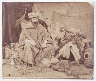
• self-portrait photograph by William Morris Grundy (1806-1859) wearing North African robes and smoking a hookah. BONKERS!

• stereoscopic photograph by W. M. Grundy looking across Mill Street to the first Town School, c1855 Photograph courtesy of the Norman Evans Collection.
Envelopes
Thought some of these definitions might be relevant later on:
http://www.google.co.uk/search?hl=en&cr=countryUK%7CcountryGB&defl=en&q=define:Building+envelope&ei=2XLMS8fnF4qy0gSZ7L3EBA&sa=X&oi=glossary_definition&ct=title&ved=0CAYQkAE
http://www.google.co.uk/search?hl=en&cr=countryUK%7CcountryGB&defl=en&q=define:Building+envelope&ei=2XLMS8fnF4qy0gSZ7L3EBA&sa=X&oi=glossary_definition&ct=title&ved=0CAYQkAE
Archive Trips
At Birmingham City Archives:
1. Copy of order of the Master of the Rolls authorising the grant from the Warden and Society of the Royal Town of Sutton Coldfield, co. War., to Sir Edmund Cradock Hartopp of Clifton, co. Glouc., bart., and Edmund Cradock Hartopp of Four Oaks Hall, co. War., of two pieces of land adjoining Four Oaks Park and being part of Sutton Park, in exchange for other lands adjoining Sutton Park. MS 3069/Acc1935-063/443143 16 November, 1827
2. Particulars and plan of sale of Four Oaks Park, Sutton Coldfield, co. Warwick. MS 20/236 1890
3. Indenture between Sir Charles Holte of Freeford Hall, co. Staff., bart., Dame Ann, his wife, and Alexander Jesson of the City of Worcester, esq., being a release from the said Sir Charles Holte and Dame Ann, his wife, of the half part of certain monies due to them from the said Alexander Jesson, guardian of Pudsey Jesson, deceased, son of Pudsey Jesson, late of Langley Hall in the parish of Sutton Coldfield, co. War., deceased, in the right of the said Dame Ann as one of the next of kin of the said Pudsey Jesson, the son; the release being in return for certain covenants on the part of the said Alexander Jesson. MS 3889/Acc 1933-055/415023 13 September 1773
4. Title deeds etc re land in Sutton Coldfield, Birmingham etc.. Records of the Jesson Family including deeds of title to property in Sutton Coldfield, 1571 - 1875. MS 1396 (69 files)
At Staffordshire Record Office, Stafford:
5. Railway Plans (British Raid Engineer's Department at Crewe) D3678/436 to 439 inclusive.
At Warwickshire County Record Office:
6. Midland Railway New Works (at Sutton Coldfield) (and duplicate). 29 Nov 1876 QS/111/345
At Walsall Local History Centre:
7. H. E. Lavender plan of villa residence for Matthew Overton, Tudor Hill, Sutton Coldfield 878/6/1 to 3 inclusive 30 Jan. 1880
At Parliamentary Archives:
8. Local Act, 35 & 36 Victoria I, c. clxxii HL/PO/PB/1/1872/35&36V1n240 1872
At Cheshire and Chester Archives and Local Studies Service:
9. Plan of Langley Hall Estate, Sutton. Plan of The Langley Hall Estate in Sutton township, property of Messrs. William Smith, exec. of Isaac Smith, dec., Samuel Smith, dec., Charles Ball and William Prichard.; Surveyor: Cawley and Firth, Macclesfield 197a. 3r. 38p.; schedule of owners, tenants, field names and acreages; names of adjacent owners; roads; woodlands and pools; block plans of buildings; boundary fences to estate; landowners' properties outlined by colour. 46" x 35" 2ch. = 1"; 40" = 1m D2817/49 1851
At Society of Antiquaries of London:
10. Abstracts of title, copy wills, a few original deeds, litigation papers and pedigrees relating to the families of Pudsey and Jesson of Langley (in Sutton Coldfield) and Wishaw, Warws. with a few earlier documents. Five bundles:- I. Original deeds, including:- Bond of John Lisle to Thomas Fulthorp to abide by the decision of arbitrators conc. the title to the manors of Wishaw and Langley and the advowson of Wishaw, etc., 1515; arbitration award, 1607/8; marriage agreement, 1624; extract from a court roll, 1680; bond, 1695; final concord between J. Edey and Thomas Pudsey, 1698; release by Mary Scarfe to Alexander Jesson, 1765; indemnity to Alexander Jesson, 1774; printed conditions of sale of Langley estate after the death of Pudsey Jesson;- II. Abstracts of title to the manors of Langley and Wishaw, 12th-16th century, 17th century-1725; marriage settlement of George Pudsey, junior, and his second wife, Mary Gibbons, 1607; copy wills of Alexander Pudsey, DD, 1720, and Alexander Jesson, 1748-51; legal opinion conc. Pudsey Jesson's will, 1759; extract from a minute book of the corporation of Sutton relating to a grant of warren to Pudsey Jesson, 1733, and later assignment of warren by Alexander Jesson to Sir Charles Holt, 1774; parcels of land in Cooper's lease; various sale particulars;- III. Legal dispute relating to the manors of Langley and Wishaw, 1621-41;- IV. Miscellaneous, including coroner's inquest on the murder of WilliamPudsey by William Elson, at Birmingham, 5 Oct. 1593; notes of baptism of Richard Pudsey, 1616, and George Pudsey, 1639; power of attorney from Alexander Jesson to Henry Shaw (both of the Middle Temple) conc. the estate of Francis Jesson, 1769; letter from Henry Shaw to Alexander Jesson, on personal and business matters, before 1774;- V. Pedigrees of Pudsey, Jesson and related families, to the 17th and 18th centuries.
Birmingham Z & postalheritage.org.uk
Yes, of course, Birmingham Z needs referencing. Can you find a place for it?
The attached shows that Francis J. Field lived on Richmond Road during the period the US were on site.
If you go to http://postalheritage.org.uk and search under 'artist', you get some history of the design process. Doesn't seem as tight (in terms of typeface, etc.) as you might think.
Like your use of 'switch', and trains do switch tracks, see: http://wapedia.mobi/en/Railroad_switch.


Birmingham Z & Stamp Design & Site
There is an association with 'Birmingham Z', but there also seemed to be 'Sutton Z' on signs when we visited the site. Is this indication of increasing localisation?
Getting a bit specific now. Was there a standard typeface used on the stamps/first day covers in the mid-20th century? This could be one way (along with a colour palette) of getting that aesthetic threaded in.
The site has a trajectory and it is the various historical events that knock it 'off course'. A patch of land's beautiful parabola was pushed one way by the railway, then another by matters postal and then another by the proposed future development. Switches. Aren't railway points sometimes referred to as switches? We switch between times to create contrasts or suggest possibilities.
Francis J. Field & John Addison & Site
Don't know whether Rosemount is Francis J. Field's house on Richmond Road or elsewhere in Sutton Coldfield. He was certainly living on Richmond Road for a big part of his life (lots of letters to him at that address).
Yes, I think that could be the same John Addison, but we need to be sure. If it is the same character, then we are clearly dealing with somebody significant to the development of railway at a national level.
And yes, the site seems to be both edge and centre at the same time. And yes, it binds locally and connects globally.
Various
Hadn't realised that Francis J. Field was in such (geographical) proximity to the site.
Rather than being a gap between all these interesting goings on, the site was at the heart of all these things and binds together places such as America and Richmond Road.
The sifting is bringing larger things to the fore. When you read through the list of the postal depot sections, it's all standard stuff until you get to deceased and casualties.
The site boundary is really interesting and puts the site at an edge position, but when taking the bigger picture, it becomes central.
From the Francis J. Field material, in addition to words, actions, and mail art, there is an aesthetic coming through in the design and colouring of labels and stamps that can filter through into the whole project.
And the purple lines too that signify a switch from air to surface mail. The site is also about a switch from rail to road.
Spiders
Where does the spider start? At the centre or the edges? The site has been created by external forces really. Its topography didn't lend itself to the laying of a railway line, it was more a case of other places were less suitable. It is or was a patch of land that was done too rather than imposing itself on others.
In terms of human interest, the site didn't really do much until the landowners made their decisions and this meant that the land was shaped for a railway yard rather than becoming another part of the Tudor Hill or Anchorage Road developments. So this decision halted the initial arrival of housing.
In terms of human interest, the site didn't really do much until the landowners made their decisions and this meant that the land was shaped for a railway yard rather than becoming another part of the Tudor Hill or Anchorage Road developments. So this decision halted the initial arrival of housing.
Grains
It seems to be that the more complex/detailed fine grain listings do something interesting in that they bind the site into the immediate neighbourhood (Tudor Hill, Richmond Road, Anchorage Road Conservation Area, and Sutton Park). This may help the development appear less like an outsider/intrusion.
Grains


1. Wolverhampton Walsall and Midland Junction Railways Act 1872 (Act of Parliament 35 & 36 Vict.)
Plans, sections, published map and book of reference of the Wolverhampton, Walsall and Midland Junction Railway
Engineer: John Addison
Staffordshire Record Office Doc Ref: Q/RUm/414
Fine Grain:
Wolverhampton Walsall and Midland Junction Railways
Midland Railway
Sutton Park Line
35 & 36 Vict
John Addison
1 July 1879
18 January 1965
2. World War II
Fine Grain:
1st PBO Sutton Coldfield
1 July 1942
15 November 1945
Holland Barracks School
Sutton Park
GPO baskets
6th October 1942
Main Sorting Building
German P.O.Ws
mail call
3. Main Sorting Building
You only start to understand context when you notice 'Deceased Section' and 'Casualty Section'!
Fine Grain:
Administration
Parcels Sorting (Section C)
Letters Sorting
Directory Service
Salvage Section
Deceased Section
Casualty Section
Watch Gallery
Loading Decks
two million people
ten tons of letter mail per day
4. Boundaries
Sutton Coldfield is sub-divided into four districts: Sutton Four Oaks, Sutton Trinity, Sutton Vesey, and Sutton New Hall (see attached plan). Our site is where Sutton Four Oaks meets Sutton Trinity. This is only interesting when you know:
"Edmund Cradock-Hartopp...developed the [Four Oaks Park] estate further and in 1827 persuaded the Corporation to allow a further incursion into Sutton Park in order to create a more pleasing oval shape to his deer park...Hartopp agreed to exchange 93 acres (38 ha) he owned adjacent to the Park near the town for 65 acres (26 ha) of Sutton Park and also to build a new entrance to the Park (Town Gate) and a new road (Park Road) linking the new entrance with the town."
It was probably this development of Town Gate and the related Park Road that led to the cutting of Richmond Road, Tudor Hill, et al later in the 19th century.
On the death of Henry Pudsey of Langley (1677), the ancient Langley Estate (a couple of miles east of our site) was split between two daughters, Elizabeth and Anne. Four Oaks Park was built by Elizabeth with her husband Henry Folliott, 3rd Lord of Ballyshannon. The architect was William Wilson, student of Christopher Wren, who had married Elizabeth's widowed mother Jane. [note: Wilson also built Moat House (as his home with new wife Jane who had been forced to leave Langley Hall by her daughter Anne) on Lichfield Road (now part of the Anchorage Road Conservation Area...this building became the School of Art and is next door to BV Grammar School].
Anyway, in 1879 Four Oaks Park was acquired by the short-lived Four Oaks Racecourse Company, who built a racecourse which opened in 1881 but had failed by 1890. The estate was finally sold to the Marquess of Clanricarde who developed it as a new residential district between 1895 and 1915.
In terms of fine grain:
Langley Hall
Four Oaks Park
Pudsey family
Sir William Wilson
Jesson family
Holte family of Aston
Bracebridge family
Anchorage Road Conservation Area
Tudor Hill
5. Francis J. Field
Because of what FJF was doing with first day covers and air mail, we have a precedent for a mail art project. That he lived on near-by Richmond Road and became the world expert on air mail, also gives us two important things:
- site-specific content for the museum; and
- a 'postal' lens through which we can see/connect some of your existing fine grain stuff (like the royal visit, the scout jamboree, Sutton Park, postal etiquettes, etc..
Two examples of this attached. Firstly FJF's Scout Jamboree cover (attachment 'Field_Jamboree') which shows that he designed this commemorative cover (he is credited at the bottom of the image). So whilst the Scout Jamboree 'belongs' to the history of Sutton Park, we can play a 'claim' game based on the equation 'Scout Jamboree + FJF + air mail + Sutton Coldfield postal services = site specific content/museum'.
Secondly, the attachment 'can30' is a letter addressed to FJF. When you read the description of this letter, you start to understand the game he was playing with air mail (his use of the ½d stamp):
"This cover is postmarked in Christchurch on 26 July 1930 and is addressed to the UK with the routing via Canadian Air Services. It left New Zealand for Vancouver on 29 July. The likely route is that it was then sent by rail to Calgary, flown from there to Winnipeg, then to Toronto by rail before being flown to Montreal. From 1927, the Canadian postal authorities had inaugurated a summer airmail service from Montreal to Rimouski which is in the St Lawrence Estuary. Mail was transferred at Rimouski to trans-Atlantic steamers and that is likely to have happened with this cover. The cover had arrived in Sutton Coldfield by 27 August. It was Francis Field's practice to affix a ½d stamp and get it postmarked to prove the arrival date. It should be noted that both the air mail label and the manuscript have been crossed out by two parallel purple lines. This was applied after the last air mail leg to indicate that the rest of the journey was by surface mail."
Interested in the "two parallel purple lines" that indicate the switch from air to surface mail, and wonder whether this could be a planting device to the embankment to the southern edge of the site.
To frame the museum offer as 'WW2 US postal services' PLUS 'Francis J. Field' gives us a very rich basis to work from.
So the fine grain here could be:
Francis J. Field
Richmond Hill
history of aerophilately
Francis J Field Ltd
The Aero Field Journal (the 'house magazine' of FJF Ltd)
FJF other publications*
commemorative covers
etiquettes
world and local events
Scout Jamboree/Sutton Park
Biographies:
FIELD, Francis John 1895-1992. For seventy years a student of airpost history and aerophilately. In 1921 he founded the firm of Francis J Field Ltd, dealing specially in air stamps. At Birmingham, in May 1923, he gave the first British philatelic talk on radio. He compiled 'A Commercial and Historical Atlas of the World’s Airways’ [1925], and was co-author, with NC Baldwin, of ‘The Coronation Aerial Post 1911’ [1934]. Works published by his firm included : ‘British Air Mails - A Chronology of the Air Posts of Great Britain and Ireland’ [1935], ‘Air Mail Labels (Etiquettes)’, ‘The Blitz Book’ [1942], ‘Great Britain and Ireland - Catalogue of Internal Air Mails 1910-41’ compiled by NC Baldwin [1942], ‘World Air Posts - A concise priced summary of the Air Post and Aviation Souvenirs of about 200 countries’ [1948], ‘British Air Mail Society Souvenir’ [1971], and from 1926 the house magazine ‘The Aero Field’. President Aerophilatelic Federation and Streetly P.S. Named in Roll of Honour of Birmingham P.S. RDP 1968.
Here's a list of FJF publications (from the British Empire to The History of Rocket & Jet Posts).
• Artic Air Mails: Field, 1968
• Atlantic Mail FLIGHTS, Fifty Years of by Baldwin,
• Australia: External Air Mails of: Baldwin, 1965
• Australia & New Zealand to Great Britain (War time services 1939-45): O. R. J. Lee
• Qantas Empire Airways Comes of Age
• Austria; An Air Mail Digest: Field
• Bermuda, Air Mails of: Baldwin
• B.E.A. Helicopter Mails: 20 Years of by Baldwin
• B.O.A.C.'s. Silver Jubilee: Baldwin
• Bridging the South Atlantic by Air Mail: A.L.Leon • Bridging the Pacific, Priced Chronology of Projected, Attempted, and Successful Pacific Flights 1919-1951: Field
• Post-War Bridging the Atlantic, 1945-50: Baldwin
• British Commonwealth Air Mail Digest 1-10: Field (updated information), 1953
• Ceylon 1873-1950: Field
• COMET-1: Baldwin (List of Flights)
• COMET-4: Baldwin
• East Africa Governors Conference Report of a Committee Appointed to Prepare a Scheme for Post-War Local Air Services in East Africa 1943. (Routes, Mileage, Tariffs)
• Ethiopia Air Mail Flights to 1934
• Air France, History of the Development of the Air Mail Services: Baldwin
• Deutsche Luft Hansa and Luft Hansa: Field
• Fanco-German War 1870-71, Balloon Builders Cachets on Letters Entrusted to Aeronauts: H.Cappart
• British Mails of The Graf Zeppelin: Field, 1987
• Great Britain, Air Letter Stamps and Services: Baldwin, 1966
• Great Britain and Ireland, Catalogue of Internal Air Mails 1910-1941: Baldwin
• British Air Mails 1946-1951: Baldwin (Priced supplement), 1955
• Fifty Years of British Air Mails 1911-1960: Baldwin
• British Inland Air Mail April 1933-April 35: Phillips
• Royal Air Force Reconnaissance Flights, Delhi to Singapore 1930: A.H.Frost
• Railway Air Services, British Inland Air Posts: Baldwin
• Hong Kong Air Post History, Priced Check List: Baldwin & Field
• Imperial Airways & Subsidiary Companies, History and Price Check List of Empire Air Mails: Baldwin
• Japan Overseas and International Flights: Field (Valuation guide)
• Libya, Air Mail Postal History of the Fezzan: N.Davies
• Malaya, Air Mails of: Baldwin
• New Guinea, Air Mail In, Includes Papua: Gisburn
• Norwegian Air Mails, A Check List of: Baldwin
• Pan American Airways: Baldwin
• Royal Air Force Covers of: Field
• Rhodesia's and Nyasaland, Air Mail History of: Baldwin
• Rocket & Jet Posts History of: Field
• British Africa, Air Mails of 1925-32: Baldwin
• South Africa, Air Posts of: Check List 1911-1956: Baldwin & Stern.
You will note that his main collaborator was Baldwin. This was:
BALDWIN, Norman Cecil 1890-1975. Company director. Specialised in airmails, and stamps with ecclesiastical designs. Wrote manual on South West Africa, ‘Abyssinia 1929-31’, ‘Air Mails of British Africa 1925-32’, ‘Malaya - Check List of Air Mail Flights’, ‘British Airmails 1946-51’, ‘Bridging the Atlantic’ [1946], ‘Post-War Bridging the Atlantic 1945-50’, ‘Great Britain and Ireland Catalogue of Internal Airmails 1910-41’, and compiled ‘Imperial Airways - A History and Priced Check List of the Empire Air Mails’ [1950]. Co-author with Francis J Field of ‘The Coronation Aerial Post 1911’ [1934].
More Questions
'Places are the rub between sites and people OVER TIME'. We don't just pin a site's identity to a handful of years for the same reason that we don't stop our investigations at the red line.
It was coal that seems to have been the 'bribe' to get people to buy the whole intrusion into the unspoilt wilderness of Sutton Park. This gave our site an area for rail/road interchange.
It was coal that seems to have been the 'bribe' to get people to buy the whole intrusion into the unspoilt wilderness of Sutton Park. This gave our site an area for rail/road interchange.
There were two or three possible routes for the railway through the Park, but this route was chosen as the line of least damage. There were also a number of conditions and these included council control over design of bridges, planting of ornamental shrubs on the embankments, and provision of a station on the west side of the park.
Friday 16 April 2010
Questions
Agree about not confining the site (or labelling it) as just a place with postal links - there is much more depth. It also works in the same way as the 'red line' we need to focus on the acres of land that are the reason for the project but we also need to keep an eye on the bigger picture.
Archive notes
Railway
There is a plan of how the proposed line will cut across fields in the Tudor Hill area with landowners named. There are also one or two documents that cover the negotiations of the route and who was for and who against. They have some very attractive architect's drawings of Sutton Coldfield main station (almost Ruskinian) but I haven't yet found any for Sutton Park Station, although this is reported to be plain in comparison to other stations.
There is a useful section about Sutton Park Station in a book called 'Cross City Connections' by a chap called Bassett. This includes some interesting anecdotes including the royal 'visit' to the sidings. Bassett also refers to a book by Hendry that has a 'wealth of information' about stations in the area. The station is referred to as a coal depot prior to becoming a parcel depot. The station was used post-War as a training school for guards and drivers of motorised vehicles. There are various small businesses shown on the 1950s plan, including a builders' merchant using the Railway Shed.
Landowners
The older maps refer to Park House as a (blade) mill. There is also Richmond House a bit closer to the site that might be worth a bit of research. The field names might have some interest. Spring Close and Pit Piece may reference the geology and the fault that runs under the woodland at the east end of the site.
Maps
The two main older maps are an 1824 Corn Rent and an 1856 Valuation. The 1950s station yard map shows some interesting landforms at the west end of the site, it looks a bit like dumped soil which may account for the odd level changes (OS maps from 1897 and 1914 also show this feature). There is also a sand pit noted behind the current garage. Some form of banking also seems to be indicated on most maps in the area at the entrance to the site. On the proposed route map mentioned above there is no indication of gradients which makes me think that the whole of the station yard was excavated. Maybe soil excavated from the main yard area was pushed to the west end and so creating the tip-like landforms there.
Newspaper Reports
A newspaper cutting from a 1966 Suttton Coldfield News rumours the closure of Sutton's Foreign Parcels Depot on the opening of a new multi-million pound building in Birmingham. Three types of mail are mentioned in this article: inward, outward and in-transit. The article is accompanied by several useful photos. More recently, in March 2008, the Sutton Coldfield Observer reported the recent closure of 'Birmingham Z' the country's "only foreign postal depot" with operations being moved to London. This mentions that 'Birmingham Z' took its name from a 'railway spur near the station where cars were shunted off for loading'.
Attachments
Attached is an overlay of the 18th century fields onto the large scale plan and an overlay of the 1950s station yard drawing. The field overlay is obviously approximate but you can see the hedge lines towards the right fit quite well with Anchorage Road and the main road and one of the hedges in the bottom left seems to shadow the brook quite well so it's not far off!


Thursday 8 April 2010
Stuff and Nonsense
Edward Croxall, the younger of Sutton Coldfield, esquire
• mentioned in the title deeds (marriage settlement of William Dilke the younger and Louisa Anne Geast) of the Fetherston-Dilke family of Maxstoke Castle, November 1795. Sheriff of the County, 1796, and maternally descended from Randal Croxall, of
Warwick, etc..
Wriothesley Digby of Meriden
Sutton Manor House stood on Manor Hill and is documented as early as 1315. This may have been built as a hunting lodge for the earl and his guests. On the other hand, the position of the manor house may suggest that this was the location of the first settlement of Sutton. After 1540 a farm-house was built here by Bishop Vesey and occupied by one of his relations. The house passed through various owners but by 1762 was in a very poor state and occupied by a farm labourer. By now the freehold was held by Sir Lister Holte of Aston Hall, after whose death in 1770 the manor-house, its mills and pools descended to WRIOTHESLEY DIGBY of Meriden. His grandson, Lord Somerville owned the estate in 1860 and built a new house to replace the old farm. That house, known as The Manor in Manor Drive, still stands and is classified as a Grade II Listed building.
• Abstract of the title of Wriothesley Digby, esq., to property situate in the parish of Sutton Coldfield, co. War. 12 October, 1769-2 March, 1818 MS 3069/Acc1935-063/443137, 1827 [Deeds of Four Oaks Halle Estate 1751-1831, Birmingham City Archives, ref" MS3069/Acc1935-063/443137]
• Copy of lease for eleven years from Wriothesly Digby of Meriden, co. War., esq., to Benjamin Browne of the Park Forge in the parish of Sutton Coldfield, co. War., of three closes of land lately forming part of the Manor House Farm in the parish of Sutton Coldfield. MS 2 April, 1819. [Deeds of Four Oaks Halle Estate 1751-1831, Birmingham City Archives, ref: MS3069/Acc1935-063/443138]
• Lease for a year from Wriothesley Digby of Meriden, co. War., esq., and the Rev. Noel Digby of Brixton, [Brighstone] in the Isle of Wight, [co. Hants.], clerk, to Sir Edmund Cradock Hartopp of Four Oaks Hall, co. War., bart., and Edmund Cradock Hartopp of the same place, esq., of lands in the parish of Sutton Coldfield, co. War., situated between the Town of Sutton Coldfield and Sutton Park, and lands adjoining the New Forge pool or Stone House Forge pool and Sutton Park, being part of Booth's farm. [Deeds of Four Oaks Halle Estate 1751-1831, Birmingham City Archives, ref: MS3069/Acc1935-063/443139]
• Release from Wriothesley Digby of Meriden, co. War., esq., and surrender from the Rev. Noel Digby of Brixton, [Brighstone] in the Isle of Wight, [co. Hants.], clerk, to Sir Edmund Cradock Hartopp of Four Oaks Hall, co. War., bart., and Edmund Cradock Hartopp of the same place, esq., of lands in the parish of Sutton Coldfield, co. War., situated between the Town of Sutton Coldfield and Sutton Park, and lands adjoining the New Forge pool or Stone House Forge pool and Sutton Park, being part of Booth's farm. PLAN. [Deeds of Four Oaks Halle Estate 1751-1831, Birmingham City Archives, ref: MS3069/Acc1935-063/443140]
• Indenture between Wriothesley Digby of Meriden, co. War., esq., Sir Edmund Cradock Hartopp of Four Oaks Hall, co. War., bart., and Edmund Cradock Hartopp, esq., being a covenant for the production of title deeds [of lands in the parish of Sutton Coldfield, co. War., situated between the Town of Sutton Coldfield and Sutton Park, and lands adjoining the New Forge pool [**NOW POWELL'S POOL'**] or Stone House Forge pool and Sutton Park, being part of Booth's farm]. [Deeds of Four Oaks Halle Estate 1751-1831, Birmingham City Archives, ref: MS3069/Acc1935-063/443141]
Nothing on the other names.
POOLS
Blackroot Pool was built in the 18th century with the primary aim of powering a watermill. The lease which allowed the pool to be constructed was granted by the Sutton Corporationin 1757 for 2 shillings (£0.10), well below what appears to have been the 'market rate'. However, the lessees were the Corporation's Warden and his nephew. The mill was initially used for leather dressing, but later became a water-powered saw mill. The modern saw mill is used to make gates, fences and other timber products from timber produced within Sutton Park. The pool is approximately 12 acres (5 hectares) in size. Angling is permitted in the pool; the main species of fish found here are Bream, Roach, Carp and Pike.
Bracebridge Pool is one of the largest in the park. The views as you approach this pool are also amongst the finest in Sutton Park. The pool takes its name from Sir Ralph Bracebridge. Bracebridge obtained a life lease on the Chase of Sutton Coldfield in 1419 and had the pool constructed to provide a good supply of bream for his family and friends. The Boat House Restaurant can be found at the edge of Bracebridge Pool. The pool is approximately 16 acres (6.5 hectares) in size. Angling is permitted in the pool; the main species of fish found here are Roach, Tench and Pike.
Little Bracebridge Pool was probably originally part of Bracebridge Pool, although it may have been partially separated by a dam to provide an area in which small fish could be reared or in which fish could fattened for the lord of the manor's table. Over time, an area of wetland has developed between the two pools. One of the most peaceful places in the park, Little Bracebridge boasts an extensive range of flowering plants which specialize in wet habitats, including some which are now quite rare, such as the Greater Spearwort.Angling is not permitted in the pool.
WARDEN AND SOCIETY
In the years after the Norman Conquest the town was the fiefdom of the Earls of Warwick and later, after their disgrace, the Crown. The influence of Bishop Vesey with Henry V111 resulted in the town gaining its independance from the Crown by virtue of the Royal Charter of 1528.
The Charter, by the standards of the day was an amazing document, establishing the right to local government by the populace through a body of 25 residents appointed to form a Corporation known as Warden and Society.
Ann and Mary Webb
These two are proving more elusive, but there might be something here:
WEBB, Misses, Sutton Coldfield, page 583 in 'The History of Warwickshire' by William West (1830).
On the basis of the Susanna Greatrex and Elizabeth Pudesy Lynch, I suspect we are dealing here with ANCESTRAL land ownership.
WEBB, Misses, Sutton Coldfield, page 583 in 'The History of Warwickshire' by William West (1830).
On the basis of the Susanna Greatrex and Elizabeth Pudesy Lynch, I suspect we are dealing here with ANCESTRAL land ownership.
Anchorage Road & Ownership
Interested to hear the importance of Anchorage Road - walked along there on Tuesday. There are still some very grand houses in different styles; noted a few 'Dutch' gables and some classic Edwardian era properties. The short history of Sutton Coldfield mentions one particular eminent resident having his stables in Anchorage Road and there are, indeed, still a few properties with high-gated garage-like entrances.
In 1824 there was also a Hannah Jackson occupying land owned by Samuel Smith. Other names associated with the fields on the site are: owners - Edward Croxall and Wriothesley Digby and occupiers - George Brown. Those are from the 1824 Corn Rent. In the 1856 valuation there is also Harriet Smith, 'Warden & Society', what looks like ? Hadhope and almost illegible M? Leader?.
In 1824 there was also a Hannah Jackson occupying land owned by Samuel Smith. Other names associated with the fields on the site are: owners - Edward Croxall and Wriothesley Digby and occupiers - George Brown. Those are from the 1824 Corn Rent. In the 1856 valuation there is also Harriet Smith, 'Warden & Society', what looks like ? Hadhope and almost illegible M? Leader?.
Elizabeth Pudsey Lynch
Elizabeth Pudsey Jesson m. Thomas Groesbeck Lynch at Saint Martin in the Fields, Westminster, on the 2nd September 1784.
Langley, Langley Gorse, Langley Heath, Sutton Coldfield
B75 - Grid reference SP149960
Le Lonkeley: first record 1253
In the middle of the 13th century Walter de Bereford held 50 acres in Langley, 'Blackmore', and Brockhurst, all in Sutton, which he gave to his son Walter. The younger Walter's son William de Bereford died in 1326 seised of the manor of LANGLEY, with a park, pond, and fishery, held of the Earl of Warwick by service of 42s. 2d. a year. His son Edmund, described as a king's clerk, in 1327 had licence to crenellate his house at Langley. The manor then passed with that of Wishaw, coming through the family of Hore to that of Pudsey. When Robert Pudsey died in 1558 he was holding it of the Warden and Fellowship of Sutton Coldfield, having settled it in 1555 on his son George, then a minor. It descended in the Pudsey family until the death of Henry Pudsey in 1677 when it appears to have been divided between two of his daughters, Anne wife of William Jesson and Elizabeth wife of Henry, 3rd Baron Folliott of Ballyshannon.
William Jesson and Anne were dealing with half the manor in 1695 and both sisters and their husbands with the whole manor in 1697, after which it appears to have passed entirely to Anne, the younger sister. Anne Jesson is said to have died in 1718 leaving a son Pudsey Jesson who died in 1748 and was succeeded by his son William Jesson. On William's death in 1786 the property was divided between his two daughters, Hannah Freeman and ELIZABETH PUDSEY, who with their respective husbands, William Pearson and Thomas Groesbeck LYNCH, were dealing with the manor in 1788. William Jesson Pearson son of Hannah and William was dealing with half the manor in 1808, (fn. 203) and on his death bequeathed his property to his 'cousin' Mary Holte Bracebridge. The other moiety was in the hands of Henry Gratien Lynch in 1816 when he conveyed it to John Stone.
It seems probable that William Jesson leased the Langley estate, on the death of his two sons, to Andrew Hacket of Moxhull and William Hacket was in 1794 paying a rent of £1 for the Hall and lands in Sutton. Andrew Hacket is said to have bequeathed the estate in 1815 to George Bowyer Adderley, who sold it in 1817 to the first Sir Robert Peel.
Deeds of the Thornton Estate, Bedfordshire and Luton Archives and Record Service ref: X825/1 date: 18 February 1801
ELIZABETH LYNCH now residing at Altena in the Empire of Germany, widow of Groesbreck Lynch late of Carmarthen Wales. Elizabeth is a daughter and coheiress of William Jesson and Hannah his wife. She is niece and Coheiress of Ann Ash, she is grandaughter of Hannah late wife of William Ash.
Records of Henry Eyres Landor of Warwick, (1780-1866) land agent and solicitor [Warwickshire County Record Office CR 237/690/2 1845]
Notes in the hand of Henry Eyres Landor entitled "Notes as to Chetwode estate": this contains a short pedigree showing that William Jesson (d. 1786) had a son who died young and two daughters, Hannah Freeman who married William Pearson (d. 1806) and had a son, William Jesson Pearson (d. 1810), and ELIZABETH PUDSEY who married Thomas G. LYNCH (d. 1798). William J. Pearson gave by will his property to Mary Holte Bracebridge, "the Chetwode District"; Mrs Pudsey Lynch's property went to Mr Lane. HEL also refers to Davidson's History of the Holtes of Aston which states that Sir Charles Holte married in 1755 Anne, daughter of Pudsey Jesson esq. of Langley, Warks, who died in March 1799, aged 65; she was the mother of Mary Elizabeth, who married Abraham Bracebridge esq. HEL did not know the relationship between Pudsey Jesson and William Jesson (d. 1786); this note is undated but post 1845.
Greatrex Family
THE ANCHORAGE / ANCHORAGE HOUSE / ANCHORAGE ROAD
‘The Anchorage’ was an 18th century mansion standing on the Lichfield Road. In 1868 it was owned by Rev C B Greatrex* and in 1869 was sold to Richard Hurst Sadler (a solicitor and s/o Richard Sadler solicitor and "landed proprietor" of High Street, Sutton Coldfield) with a view to redevelopment. In the event the old house was retained and sold to Thomas Moxham a gunmaker and maltster (living High Street in 1871 & 1881 Census Returns and died 1886).
Sadler proceeded with plans to develop the extensive fields to the west of the Lichfield Road and in 1870 laid out Anchorage Road roughly on the line of the Reddicroft path to Tamworth Road. Building plots were offered for sale, one of the sale conditions being that no house should cost less than £500. The properties built for middle class occupation were mostly individually architect designed , many in the Arts and Craft style. The architects included all the best of the local professionals including Bateman, Crouch and Butler and Bidlake.
Four houses were built in 1872/3. Wellington Terrace on the Lichfield Road was completed in 1885. The rest of the Anchorage Road house were erected between 1888 and 1913.
The article ‘ The Anchorage Road Estate’ by Janet Lilleywhite in ‘Scenes of Suttons Past’ published by the Sutton Local History Research Group provides much detail of this development.
The biggest house on the road, ‘Oakhurst’ built for George Lowe, became the local hospital maternity unit in 1946 (it had four wards and fourteen beds) and remained so until 1967 when the new maternity block was built at Good Hope hospital. Subsequently and not at all unusually Oakhurst was converted to apartments.
The old ‘Anchorage House’ was demolished and the new firestation was built on the site in 1963 [check Google maps with postcode B74 2NT, opposite Bishop Vesey's Grammar School).
*This Rev. Charles Butler Greatrex was born in Abberley, Worcestershire, in 1821 the s/o Charles Butler Greatrex and Mary Ditchburn, and had an interesting life.
In April 1846, he emigrated to Quebec, returned to England almost immediately, and emigrated a second time to New York in November 1847. In about 1855, he was ordained by the Bishop of Lichfield and became the curate at Loppingham in Shropshire in 1861, the rector at West Camel in Somerset in 1881, a clerk in Holy Orders in Hope Baggot, Shropshire, in 1891, and died in Croydon in 1898. He was also a poet and writer:
"ABELL, F[rank] (i.e. Charles Butler Greatrex, 1832?–98). Greatrex, who also used the pseudonyms ‘Lindon Meadows’ and ‘Abel Log’, was born in Birmingham, the son of a lieutenant in the Royal Marines. On graduation from King’s College, London he took orders in 1855 after which he held a succession of livings, mostly in the West Country. A writing parson of the hearty Charles Kingsley* stamp, he published a number of volumes of humorous sketches, random tales and boister- ous verse. He also wrote (and himself competently illustrated) a successful novel, The Adventures Of Maurice Drummore (1884). This rollicking story of a Royal Marine evidently drew on his father’s experiences."
His father, also Charles Butler Greatrex (born Birmingham 1787) was listed in the 1851 Census as a "General Medical Practioner prior to 1815", when he was living on the High Street in Sutton Coldfield, and is also recorded as a First Lieutenant in the Royal Marines in the Army List for 1839 (having joined the RM on the 1st June 1810).
This elder Charles Butler Greatrex (doctor and soldier) was the s/o of yet another Charles Greatrex who was born 1760 and one time "druggist, dealer in tea, etc" at 33 Bull Street, Birmingham, and his wife Susanna [unknown surname].
This will be your Susannah Greatrex, but I can't find anything else on her except that she is listed in 'The History of Warwickshire' by William West (1830) as "GREATREX, Mrs Susan, Sutton Coldfield", page 583.
Looks like she died in early 1838, and I would suspect that 'The Anchorage' was property that came through her blood line.
See:
http://www.brumagem.co.uk/ac_Anchorage-Road_Sutton-Coldfield_Birmingham.htm
‘The Anchorage’ was an 18th century mansion standing on the Lichfield Road. In 1868 it was owned by Rev C B Greatrex* and in 1869 was sold to Richard Hurst Sadler (a solicitor and s/o Richard Sadler solicitor and "landed proprietor" of High Street, Sutton Coldfield) with a view to redevelopment. In the event the old house was retained and sold to Thomas Moxham a gunmaker and maltster (living High Street in 1871 & 1881 Census Returns and died 1886).
Sadler proceeded with plans to develop the extensive fields to the west of the Lichfield Road and in 1870 laid out Anchorage Road roughly on the line of the Reddicroft path to Tamworth Road. Building plots were offered for sale, one of the sale conditions being that no house should cost less than £500. The properties built for middle class occupation were mostly individually architect designed , many in the Arts and Craft style. The architects included all the best of the local professionals including Bateman, Crouch and Butler and Bidlake.
Four houses were built in 1872/3. Wellington Terrace on the Lichfield Road was completed in 1885. The rest of the Anchorage Road house were erected between 1888 and 1913.
The article ‘ The Anchorage Road Estate’ by Janet Lilleywhite in ‘Scenes of Suttons Past’ published by the Sutton Local History Research Group provides much detail of this development.
The biggest house on the road, ‘Oakhurst’ built for George Lowe, became the local hospital maternity unit in 1946 (it had four wards and fourteen beds) and remained so until 1967 when the new maternity block was built at Good Hope hospital. Subsequently and not at all unusually Oakhurst was converted to apartments.
The old ‘Anchorage House’ was demolished and the new firestation was built on the site in 1963 [check Google maps with postcode B74 2NT, opposite Bishop Vesey's Grammar School).
Notes:
*This Rev. Charles Butler Greatrex was born in Abberley, Worcestershire, in 1821 the s/o Charles Butler Greatrex and Mary Ditchburn, and had an interesting life.
In April 1846, he emigrated to Quebec, returned to England almost immediately, and emigrated a second time to New York in November 1847. In about 1855, he was ordained by the Bishop of Lichfield and became the curate at Loppingham in Shropshire in 1861, the rector at West Camel in Somerset in 1881, a clerk in Holy Orders in Hope Baggot, Shropshire, in 1891, and died in Croydon in 1898. He was also a poet and writer:
"ABELL, F[rank] (i.e. Charles Butler Greatrex, 1832?–98). Greatrex, who also used the pseudonyms ‘Lindon Meadows’ and ‘Abel Log’, was born in Birmingham, the son of a lieutenant in the Royal Marines. On graduation from King’s College, London he took orders in 1855 after which he held a succession of livings, mostly in the West Country. A writing parson of the hearty Charles Kingsley* stamp, he published a number of volumes of humorous sketches, random tales and boister- ous verse. He also wrote (and himself competently illustrated) a successful novel, The Adventures Of Maurice Drummore (1884). This rollicking story of a Royal Marine evidently drew on his father’s experiences."
His father, also Charles Butler Greatrex (born Birmingham 1787) was listed in the 1851 Census as a "General Medical Practioner prior to 1815", when he was living on the High Street in Sutton Coldfield, and is also recorded as a First Lieutenant in the Royal Marines in the Army List for 1839 (having joined the RM on the 1st June 1810).
This elder Charles Butler Greatrex (doctor and soldier) was the s/o of yet another Charles Greatrex who was born 1760 and one time "druggist, dealer in tea, etc" at 33 Bull Street, Birmingham, and his wife Susanna [unknown surname].
This will be your Susannah Greatrex, but I can't find anything else on her except that she is listed in 'The History of Warwickshire' by William West (1830) as "GREATREX, Mrs Susan, Sutton Coldfield", page 583.
Looks like she died in early 1838, and I would suspect that 'The Anchorage' was property that came through her blood line.
See:
http://www.brumagem.co.uk/ac_Anchorage-Road_Sutton-Coldfield_Birmingham.htm
Organising
Posting, Sorting, Delivering
Posting as a research phase during which we post information to a blog that can be accessed by the project team. Research includes on-site investigations of flora & fauna, initiating a mail-art programme, materials audit, etc..
Sorting the research information into useful resource relevant to the programme needs of the project team and the July consultation event.
Delivering the deliverables, including design team collaboration, outlining the museum offer, a publication and/or exhibition boards for the July consultation event, dealing with legacy issues, etc..
'Posting, Sorting, Delivering' is stronger than 'Post, Sort, Deliver'...'doing' words are good!
Lady Landowners
The fields that fall under the exact site seem to be owned / occupied by a mixed bag of people and no sign of John Wiggan but (surprisingly?) among them four women: Susannah Greatrex, Elizabeth Pudesy Lynch, Ann and Mary Webb.
Wednesday 7 April 2010
Interests
Particular areas of interest so far are the pre-rail and natural history stories, including the allotments and 'wild' area at the approach end.
The 1950s plan doesn't give much clue to that banking (the 1897 and 1914 OS maps do indicate it, though) but it does have marked 'GH Dykes Coal Office' on the opposite side of the road and 'Pratts Depot' and 'Shell Mex Depot' in the now wooded area.
The growth and decline of the railway and the associated languages (visual and written) also interests me.
Arrangements
Yes, 'posting / sorting / delivering' is brilliant! Let's go with that.
FUNCTIONALITY
A. the blog is the key. It is a research conversation between the two of us which is also open to BPN and other project partners (who are free to 'sort' as and when is useful to their needs, and outside of the design team workshop sessions).
B. the take-away publication for the July consultation is a highlights summary taken from the blog.
C. our original material for the blog (visuals and texts) resources future museum display.
Tuesday 6 April 2010
Bricks and Dags
The goods shed bricks I think are in English Bond and those wooden valences are called dags apparently.
Fault Line, Field names & Holte
Birmingham Archives have a few maps of use. Quick and very crude overlay attached puts the site mainly on land owned by Sir John Lister Holte of Aston Hall in the mid 1700s. Also attached is an excerpt from the 1977 map of 1760 fields that they have at Birmingham and the site is mainly in 'Spring Close' and 'Eight Acres'. The name Tudor Hill doesn't seem to appear on maps until after about 1860.
On matters geological, the BGS map of the area shows a fault line running across the site north south roughly along the line of the underground sewer. The fault seperates Kidderminster formation sandstone from Bromsgrove formation sandstone.
On matters geological, the BGS map of the area shows a fault line running across the site north south roughly along the line of the underground sewer. The fault seperates Kidderminster formation sandstone from Bromsgrove formation sandstone.
Archives & 'Posting / Sorting / Delivering'
The library local history section had quite a lot of interesting stuff which I won't go into detail with now but just to whet your appetite includes: King George VI and Queen Mary sleeping on the Royal Train in the Sutton Park sidings; a fairly detailed drawing of the station yard buildings owners/uses; documents about the proposal for the railway including a map with the line overlaying the fields, 'Opened by Censors'.
One other thing I noticed was in the gardens to the right as you leave the site (where we looked at the level change) there is a stream/ditch (with running water) that heads for the site. I guess this might be the underground sewer as there is no other waterway marked. I also can't see anything in the way of gravel pits marked on maps in the low areas although some odd embankments are marked at the end of the site.
In terms of approach how about Posting / Sorting / Delivering? Posting is the research phase when we literally post information to the blog. Sorting the information is for useable material, and then Delivering is about the deliverables. In terms of the work, things hinge a bit on what others want us to put forward for the July consultation.


Sunday 4 April 2010
Posting
Agree about the idea of using a blog. It is a nice simple way to share files if nothing else, but also its chronological structure will show how the picture we create builds over time.
The question about the 1st Base Post Office was more to do with the site limitations. Why, given the need to keep expanding the accommodation, did they select such a confined site. Surely there was somewhere equally well connected but with much space. Could be that BPO was never meant to expand to such an incredible extent. Having said this, given the problems encountered by the Americans, why did the British then use the site for the same purpose? Is it just proximity to railway and location near centre of country?

The question about the 1st Base Post Office was more to do with the site limitations. Why, given the need to keep expanding the accommodation, did they select such a confined site. Surely there was somewhere equally well connected but with much space. Could be that BPO was never meant to expand to such an incredible extent. Having said this, given the problems encountered by the Americans, why did the British then use the site for the same purpose? Is it just proximity to railway and location near centre of country?

Birmingham Z
I put Birmingham Z at the top in the end as I felt that this is why we are here. Birmingham Z came before the mail sorting as I seem to recall it was a railway spur that gave its name to the site.
Military Sutton
Why did the US come to Sutton Coldfield? Not sure, but it is centrally located and far enough away from significant industrial cities to avoid bombing raids.
Also military activities have been associated with SC/Sutton Park since at least the 19th century...
Ryknield Street, built as part of the Roman conquest of the West Midlands, just after AD 43, was a military road joining forts at Wall (near Lichfield) and Metchley, on Vincent Drive in Edgbaston. The road comes through north Birmingham by way of Handsworth, Perry Barr and Kingstanding entering Sutton Park near Banners Gate. It crosses the bog, heathland and golf course on the west side, leaving on the north side of the park.
The Park was used for military training in the 19th century. There was a volunteer camp near Streetly and a firing range was established near Westwood Coppice.
In the First World War, huts were built, first for the Birmingham City Battalion and then as convalescent camps for the Australian and New Zealand wounded. There was also a prisoner of war camp near Longmoor Pool.
22/04/1918 Pup B5943, of 28 Training Squadron, dived into the ground while attacking a target in Sutton Park killing the pilot, Sgt Henry Joseph Birtles.
In the Second World War, the Park was used as a training ground for the regular troops and the Home Guard, for testing tanks and as an internee camp for Italians and Germans.
"This tablet is erected to commemorate the occupation of this park from 1914 to 1920 by His Majesty's troops. The park was placed at the disposal of H.M. government entirely free.
Over 50,000 of H.M. troops occupied the various camps constructed. The Birmingham city battalions of the Royal Warwickshire Regiment received their training here and were followed
by other units. For a considerable period the camps were used for convalescent officers and men -- and New Zealand troops also were in occupation prior to their return home. The council of the royal town received the thanks of the War Office for their patriotic action."
See also:
http://www.lhi.org.uk/docs/Walking_in_their_Footsteps.pdf
http://www.mikekemble.com/sutton/park1.html
http://www.fospa.org.uk/47ad.html
http://www.prismbrands.com/giventake.pdf
Saturday 3 April 2010
Sorting Office Plan

The 'plan' jpeg is the layout of processes as mentioned earlier using the website as a repository and sorting office. This then leads to the various potential outputs, milestones.
At the top of 'plan' I've used 'outward' and 'inward' this is/was the rough sorting into mail that would go onto lorries and go far afield (outward) and items for the 'walks' i.e. local would be 'inward'. Seems a nice way to separate the two sections but keep them in our depot. By the way is the site a Sorting Office or a Delivery Office?
Postal rounds are/were apparently referred to as 'walks'.
The document below is an attempt to rationalise themes so far and find some key ones to help identify our etiquettes. Please add further subjects. Going with matters postal I wonder if: Address - refers to matters of place; Sender - people; Item - machines and objects; etc. Any thoughts? I definitely agree that our sorting office should contain all manner of things and if at the end of the day it isn't used we just bag it up and pile it outside the shed (obviously others can have a quick rummage first).

One thing that has been nagging at me. Why on earth did the US army choose this site as their main postal centre? And the British army seemed to follow (how long was this for?).
Sorting Office
Website as chanced upon sorting office "filling up with all manner of information and then we direct it to where that knowledge is required". This is a great metaphor. And from that, everything becomes possible.
Need to agree on the sorting categories...landscape, history, social history, etc., but find better and more imaginative terms to work with. Like the phrase 'air mail etiquettes' [http://en.wikipedia.org/wiki/Airmail_etiquette], and maybe we agree a set of new etiquettes. It would be great to work on one of these projects via the notion of etiquettes! It would also be good to have a sorting office that was big enough and random enough to include, for example, a history of Francis J. Field. Such off-site but related 'etiquettes' would help broaden the context.
And yes, what the work is also about the wider Sutton Coldfield context and beyond (otherwise it will all become claustrophobic and over precious!).
Much better for us to work on content development which (as you say) "we direct it to where that knowledge is required." This does mean that we will have to have an opinion on everything, but why change the habit of a lifetime!
Yes about the ecology etc. and the link to the Park. We have to make this connection even if the development can't.
Subscribe to:
Posts (Atom)